Stopping Sprawl Development – SB 743 Explained
A recurring theme in environmental activism in the San Diego Region has been the effort to prevent sprawl development in the rural part of the county. This has taken on a new urgency in recent years, as catastrophic wildfires have become more frequent, and the reality of climate disruption has begun to sink in. The long-standing desire to protect and preserve some of our natural lands for habitat and recreation, coupled with a desire to maintain our agricultural heritage, has now been joined by recognition of the folly of building in harm’s way, and the need to sharply reduce burning of fossil fuels for transportation.

Past efforts in the form of ballot initiatives, project-by-project litigation, and citizen activism have been only partly successful. We have seen continued loss of natural and agricultural land to inefficient suburban sprawl, not just in our county, but statewide. Fortunately, a progressive state legislature has recognized the problem, and given us some legal tools to help fight climate change. These can have a secondary benefit of helping us to preserve some of our wildlands for future generations. One of the best is known as SB 743.
SB 743 changes the way transportation impacts are analyzed under the California Environmental Quality Act, or CEQA. Instead of looking at how the traffic generated by a project will impact the level of service (LOS) on neighboring streets and intersections, the new method looks at the vehicle miles traveled (VMT) that will result from the project.
Our current focus is on how San Diego County will implement SB 743. That is where it will have the largest impact on land use decisions. In June of 2020, the previous County Supervisors approved a faulty implementation plan that exempts most development in the unincorporated county from VMT analysis. They made that decision despite extensive public comments urging them to adopt a better plan. Several of the member organizations in our coalition filed lawsuits objecting to their flawed plan. The new County Supervisors have asked county staff for a reconsideration of the SB 743 implementation plan. That is expected to come before the Board at their meeting on May 19. That meeting is our opportunity to advocate for an implementation that will help fight climate disruption, reduce loss of life and property in wildfires, protect natural lands, and preserve local farms.
To advocate for a good plan, you need to understand how SB 743 works. When a development project is proposed, the first step is to determine whether it requires a VMT analysis. Certain types of projects are exempted by the law, such as a single home, a small local retail store, or a 100% affordable housing project.
If a project is not in one of the exempt categories, then the VMT created by the project must be evaluated. The rules for that evaluation are not specified in the law. The law delegated the job of specifying the details to the Governor’s Office of Planning and Research, or OPR. The OPR published guidelines in 2018 establishing the rules for local jurisdictions. Each local jurisdiction has some latitude in establishing the parameters for deciding which projects need a full analysis, and what constitutes a significant impact that must be mitigated.
The next step in evaluating VMT for a residential project is to compare its expected VMT to the average VMT for the city or county where it is located. The expected VMT is based on the actual VMT for existing development in the immediate vicinity of the project site. If the expected VMT is below the average for the jurisdiction by a specified percentage, the project is presumed to have a less than significant impact.
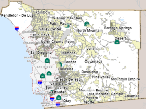
To facilitate this evaluation, the jurisdiction may publish maps showing the VMT for areas within the jurisdiction. The San Diego County map can be viewed here. If the map shows that the project is in a VMT-efficient area, that is, an area where it is not necessary to drive long distances for daily needs like work, school, or grocery shopping, no further analysis is required. The project is assumed to not have a significant impact.
The three most important parameters that local jurisdictions must select are:
- The geographic area for determining the baseline average VMT.
- The percentage below the average that qualifies a project as exempt.
- The number of average daily trips that qualifies a residential project as exempt because it is small.
On the selection of geographic area, the OPR guidelines state “For residential projects in unincorporated county areas, the local agency can compare a residential project’s VMT to (1) the region’s VMT per capita, or (2) the aggregate population-weighted VMT per capita of all cities in the region.” The Transportation Study Guide adopted by the county in June 2020 ignored these guidelines and selected only the unincorporated portion of the county to compute the baseline average. This results in a higher baseline average, exempting more areas from VMT analysis.
On the percentage, the OPR guidelines state “Based on OPR’s extensive review of the applicable research and literature on this topic, OPR finds that in most instances a per capita or per employee VMT that is fifteen percent below that of existing development may be a reasonable threshold.” The County accepted this guidance.
On the ADT that defines “small”, the guidelines state “Absent substantial evidence indicating that a project would generate a potentially significant level of VMT, or inconsistency with a Sustainable Communities Strategy (SCS) or general plan, projects that generate or attract fewer than 110 trips per day generally may be assumed to cause a less-than-significant transportation impact.” The County accepted this guidance, but some of us believe that this threshold is too high for the rural areas of the county where everything is a long drive away.
At the County Board of Supervisors meeting on May 19th, members of the Quality of Life Coalition will be urging the Supervisors to adjust the Transportation Study Guide to specify that the entire County, including the cities, be used to calculate the baseline average, and that it specify a smaller number of daily trips as the definition of a small project. Plan to join us and speak in support of our request.
Resources and More Learning about SB 743
Start with this short video that explains what VMT is in less than 2 minutes.
https://cal.streetsblog.org/2019/01/23/video-introducing-vmt-vehicle-miles-traveled/
Then watch this excellent 10-minute video from Caltrans and the Governor’s Office of Planning and Research that explains what SB 743 does.
https://www.youtube.com/watch?v=o1zlcuMRySo&feature=youtu.be
For a deeper dive, here are some resources:
The law: https://leginfo.legislature.ca.gov/faces/billNavClient.xhtml?bill_id=201320140SB743
SB 743 Implementation Resource Project: https://www.sb743.org/the-project
Governor’s Office of Planning and Research web site: http://opr.ca.gov/ceqa/updates/sb-743/
Implementation guidelines: http://opr.ca.gov/docs/20190122-743_Technical_Advisory.pdf
Discussion on guidelines: https://www.jdsupra.com/legalnews/natural-resources-agency-finalizes-47470/
Caltrans: https://dot.ca.gov/programs/transportation-planning/office-of-smart-mobility-climate-change/sb-743
CEQA Guidelines Section 15064.3
https://govt.westlaw.com/calregs/Document/I43ABB2050A37472B90E4B2F4F9D8EF29?viewType=FullText&originationContext=documenttoc&transitionType=CategoryPageItem&contextData=(sc.Default)
More than you want to know
https://www.sb743.org/resources
Did you see these other posts?
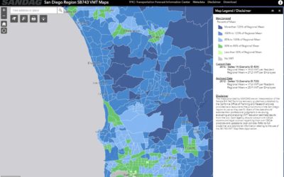
SANDAG Released SB 743 VMT Maps
SANDAG has released the SB 743 VMT maps for both Series 14 and the historical Series 13.SANDAG has released the SB 743 VMT maps for both Series 14 and the historical Series 13....
SANDAG has rolled out the Climate Action Data Portal
SANDAG has rolled out the Climate Action Data PortalThe Climate Action Data Portal is an online resource for climate planning data for the San Diego region. Its purpose is to provide easily accessible, best available data to assist local jurisdictions in climate...
Recent Comments